When Isabella de Fortibus, Countess of Devon, first built a weir across the River Exe to power her mills around 750 years ago it isn’t clear whether she set out to prevent ships – and their cargoes – reaching Exeter’s city walls. A gap may have been left through which boats could pass.
After her cousin Hugh de Courtenay inherited her estate, however, he and his son did block the river so ships would have to land goods – and pay tolls – at the quay he had built downriver at Topsham instead.
Their lucrative efforts prevented ships reaching Exeter for 250 years as the city repeatedly, and unsuccessfully, petitioned the king to remove the obstructions.
Permission was eventually granted to reopen the waterway after Henry Courtenay’s possessions reverted to the Crown, following his 1538 attainder and execution. But restoring the navigation proved impossible because the river channel had silted up.
As a result the city commissioned Welsh engineer John Trew to construct a canal to bypass the weirs, making it among the first inland waterways to be built in Britain when it opened in 1567.
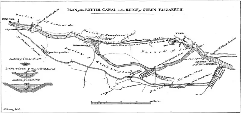 Plan of Exeter Canal in the reign of Queen Elizabeth. Image: Topsham Museum.
Until its enlargement and extension in 1701, the canal joined the river just below what had already long been known as Countess Wear.
The bridge that was built there in the 1770s to replace a river fording point probably led to another bridge which crossed the canal. A swing bridge was certainly in place by the 1820s, when the canal was improved and extended again to join the River Exe in deeper water at Turf Lock.
The swing bridge which is still in use today, one of two Bridge Road canal crossings, replaced this bridge in 1936 when the pre-war Exeter Bypass was constructed and Countess Wear bridge was also widened to carry more traffic.
This new route between Pinhoe and Peamore was intended to relieve congestion, especially during the summer when newly car-owning holidaymakers would cause city centre traffic jams trying to cross the River Exe, but soon itself became notorious for tailbacks of several miles in both directions.
A bascule bridge was added beside the swing bridge in 1972 in response, just as most freight transport on the canal was coming to an end.
It was intended as a temporary measure until the completion of the M5 motorway viaduct so did not undergo comprehensive load checks. A 2018 inspection later found that the bridge was in “fair” condition but raised “numerous concerns regarding safety aspects”.
Despite an earlier 2015 inspection of the older swing bridge finding “several areas of significant section loss and corrosion caused by water ingress”, a 2021 Devon County Council report concluded that the newer bascule bridge was “the one most at risk”.
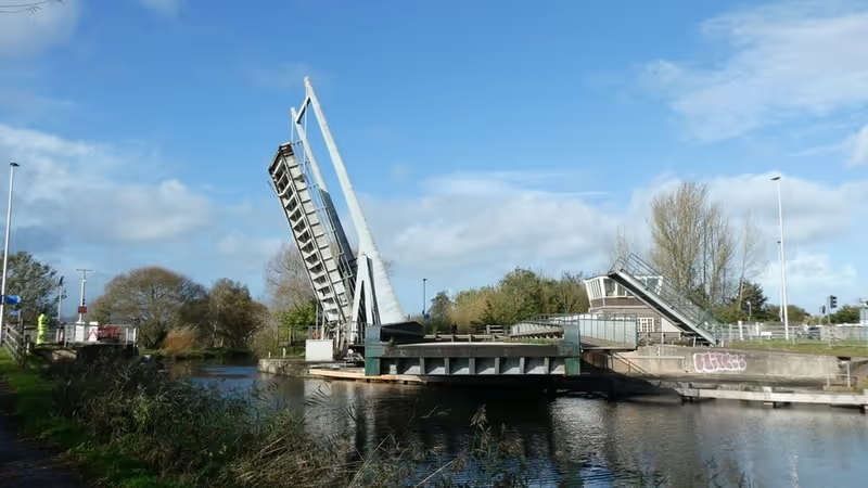 Exeter Ship Canal swing and bascule bridges in open position.
Photo: David Smith under Creative Commons license.
The M5 viaduct opened in 1977, relieving congestion across both bridges until National Highways identified problems with the viaduct’s carrying capacity during a structural assessment, forcing the introduction of lane restrictions in 2019.
Devon County Council said in 2021 that a “strengthening scheme” had “restored the structure to full capacity”. But it added that, in the twelve months to the end of July that year, there had been 26 viaduct closures – one of which was unplanned – which had required the use of the A379 diversion route across the bridges.
It also said that the M5 became “overwhelmed” between junctions 29 and 31 during peak tourist periods, resulting in traffic “cascading” on to local roads.
By then National Highways had concluded that Bridge Road would have to “continue to provide additional capacity for cross-river traffic and improve resilience in the event of further works on the viaduct”.
The county council’s response was that it was “reasonable” for the Strategic Road Network to rely on local roads to accommodate extra traffic because widening this stretch of the M5 was “unlikely”.
 M5 viaduct crossing Exeter Ship Canal.
Photo: David Smith under Creative Commons license.
The A379 and its bridges are consequently designated as part of the Major Road Network, which combines local authority-controlled roads with the National Highways-controlled Strategic Road Network of motorways and major A-roads.
The designation is intended to enable appropriate direction of central government funding towards economically-critical road infrastructure.
Devon County Council thus describes Bridge Road – with an average of 37,000 motor vehicles a day crossing the bridges and peak one-way flows of up to 1,700 vehicles an hour – as an “important diversionary and overflow route for the M5 viaduct”.
It adds that the A379 is “essential to the delivery of thousands of dwellings around the eastern fringes of Exeter”, is a “key bus corridor” used by up to eight buses an hour during morning peaks and is part of several cycle routes, with around 100 pedestrians and 200 cyclists crossing the road at the bridges each day.
Almost as an afterthought, its 2021 report also mentions that Exeter Ship Canal passes under the two canal bridges beside Countess Wear.
While it acknowledges that the canal is “used frequently by waterborne traffic” and notes that the bridges must be opened to enable boats to pass, a navigation right established in 1829 which it admits “must be maintained in perpetuity”, it barely seems aware of the canal’s social and economic value – not only its past and present value but its potential future value too.
It nevertheless emphasises the adverse “social and economic impacts” of “extensive disruption” which affects local roads when the canal bridge faults occur, which they often do.
It says there have been “numerous” instances when engineers have had to intervene to close them because of operating system problems and that they have become stuck in position “at least four” times in recent years, causing long delays.
They have also required more than 100 maintenance visits since 2020.
But it also says that extensive disruption and adverse social and economic impacts occur when the bridges are opened to allow vessels to travel along the canal, and that the pedestrian and cyclist crossings at the bridges create conflict with motor vehicles and cause delays too.
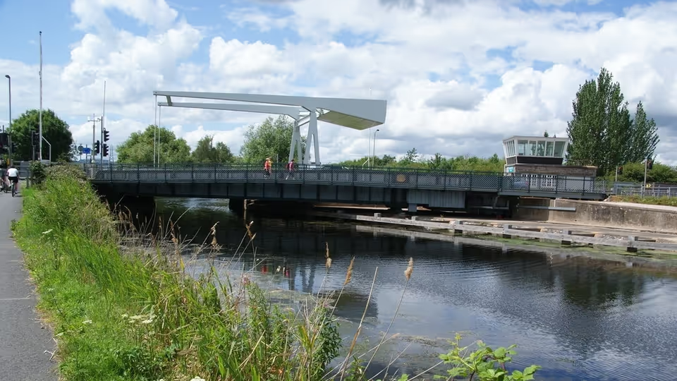 Exeter Ship Canal swing and bascule bridges in closed position.
Photo: Bill Boaden under Creative Commons license.
Devon County Council’s 2021 report considers three options in response to the reduced resilience and strategic significance of the A379 swing and bascule bridges.
While it includes refurbishment as a low-cost option, it points out that this would entail permanent closure of one of the bascule bridge carriageways, reducing the crossing’s capacity and diverting traffic on to the M5 as a result – instead of continuing to provide additional capacity and allowing the diversion of traffic off the M5, as National Highways wants.
So it instead makes the case for replacing both bridges, on the basis that Department for Transport funding would have to cover most of the project costs whichever option it pursues.
It says these costs were “in the order of £20-30 million” in 2021 against the £6.5 million capital funding it received that year for major bridge repairs and replacement works, and points out that if it “contributed all of its bridge maintenance allocation for six years on this single project, the condition of the remaining 3,500 bridges that Devon maintains would deteriorate significantly”.
It also says that replacing both bridges would allow it to “raise the height of the road over the canal, enabling the diversion of the canalside pedestrian/cycle path underneath the road and the removal of the existing signalised crossing”.
Doing so would “reduce the number of times the bridges would need to open for vessels along the canal because of the increased headroom”, “improve safety and reduce delays for pedestrians and cyclists” and “reduce disruption to vehicular traffic”, thus “increasing journey time reliability for both canal and road users”.
It even indirectly acknowledges that this approach would “radically change the outlook for the canal’s future and bring benefits to the region’s economy and environment” by paraphrasing representations by the Inland Waterways Association and Friends of Exeter Ship Canal.
 Exeter Harbour Board member Shelley Rhodes demonstrates current Exeter Ship Canal swing and bascule bridge air draft restrictions. Photo: Jane Evans, Exeter Canoe Club.
But that was 2021, and costs have risen since. Last year’s Department for Transport funding announcement put the A379 bridges scheme on hold, along with several other South West schemes.
In March this year, however, the Department for Transport confirmed that the scheme would go ahead after all, subject to a final business case approval, a decision for which Exeter MP Steve Race initially sought to claim credit.
He has since, however, criticised the county council for its “lack of ambition” after it became clear that a £50 million Department for Transport project cost cap – and the requirement that Devon contributes 15% of the total – means that the county council is only proposing to replace the crossing with two new bascule bridges without raising the height of the road over the canal.
The county council has published a summary justification for ruling out all the other options alongside a public consultation it is holding on its plans. It claims that simply replacing the bridges at the existing road level – which it says will cost £42 million, towards which it is expected to contribute £6.3 million – “best meets the scheme objectives” and is “more cost-effective” than the other options.
Nowhere in its consultation materials does it explain that raising the road level to provide adequate air draft for most boats, as well as paddleboards and other vessels, and headroom for pedestrians and cyclists to continue unimpeded along the canal, would significantly reduce the number of times Bridge Road motor traffic is routinely stopped each day.
Nor does it mention that doing so would largely resolve the tension between the rights of waterways users to navigate the canal and National Highways’ desire to keep the traffic flowing by raising the bridges as infrequently as possible.
Instead, the county council consultation takes a leaf out of the city council’s book by mostly asking for multiple choice responses to questions about an outcome it has already decided.
Unlike recent city council consultations, however, some open questions remain which offer the opportunity to comment freely to those who have more to say than the tick-box approach invites.
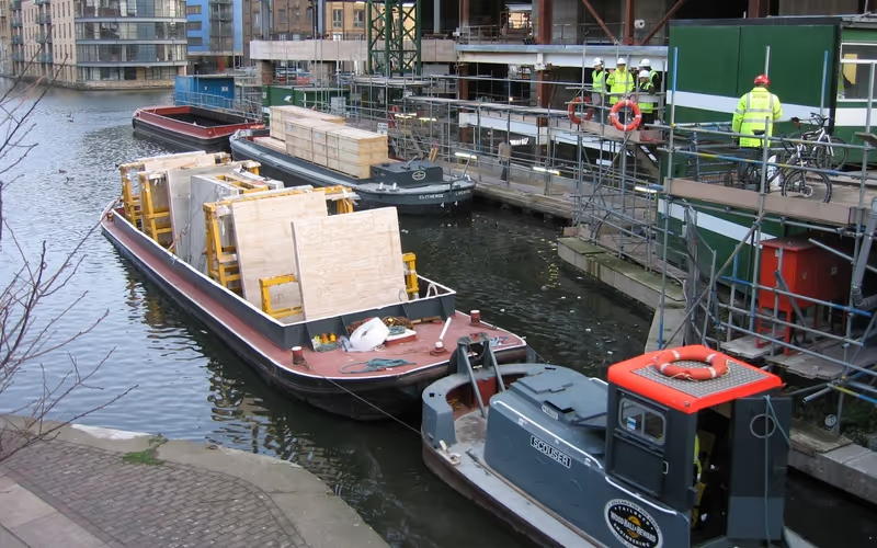 King’s Place redevelopment construction materials being delivered by barge on Regent’s Canal in King’s Cross, London. Photo: Wood, Hall & Heward.
When Exeter Harbour Board met in March, just before the consultation began, John Monks of Friends of Exeter Ship Canal presented it with a rather more productive vision for the canal’s future than Devon County Council is apparently willing to countenance.
He said that raising the road level at the bridges to provide just three metres of air draft above the water level would future-proof the canal’s potential to bring back commercial uses and facilitate access to Exeter Quay – and its specially-designated Heritage Harbour – in the heart of the city.
He pointed out that waterways freight transport is now recognised as an essential part of the future because of its economic, social and environmental benefits. He said barges generally move more per load than lorries, use less fuel and generate less pollution, while fewer HGVs city centres means improved air quality and enhanced health and well-being.
He invited harbour board members to envisage a depot outside Exeter bringing goods into the city by water instead of road – there could hardly be a better way to transport construction materials to the Water Lane development site with its limited highways access.
He also cited the benefits that easier canal navigation would bring to nautical and leisure businesses in the canal basin and Exeter Quay – not to mention the estuary’s commercial farming and fisheries.
Board member James Prescott commented that the additional costs of raising the road level at the bridges could and should be offset against the economic, social and environmental benefits of doing so. But Devon County Council has apparently rejected this option without taking them into account.
Nor does it seem to have assessed the impact on road network resilience of Bridge Road traffic stopping hundreds of times a day for pedestrians and cyclists, and any vessel requiring more air draft than a kayak, for at least another 60 years, the expected lifespan of the new canal crossing.
Despite offering only a single replacement option which builds in routine traffic disruption at the bridges and wrecks the city’s aspirations for Exeter Ship Canal, its heritage harbour and towpath active travel, Devon County Council claims consultation feedback “will be used to help shape the final plans” before they are submitted to the Department for Transport later this year.
It says construction, which will take two years, is not expected to begin until spring 2029 – and will involve closing first one, then the other, canal bridge. It even admits that the ability to open the bridges to allow larger vessels to pass underneath “may be lost at times” during the project.
If the ghosts of Countess Isabella’s Courtenay cousins were looking on, they would surely be delighted.
Devon County Council’s consultation on its plans to replace the A379 bridges over Exeter Ship Canal is open until 11.59pm on Monday 27 July 2026.