An Exeter City Council decision to waive an Environmental Impact Assessment of its own proposals to develop the Liveable Exeter Southgate site has been overturned by the Secretary of State for Levelling Up, Housing and Communities.
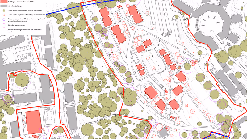
The 3.5 acre Southgate site, which is allocated for development in the new Exeter Local Plan, includes the Magdalen Street surface car park and the Western Way gyratory that surrounds it as well as a rough sleepers night shelter. A remodelled highways layout would replace the existing gyratory with a series of T-junctions.
The city council put forward outline proposals to develop the site, which meets the Exeter Development Fund criterion of being part-owned by two public authorities – the city and county councils – in September last year.
It said it would build up to 200 new flats in high-rise tower blocks there, although the 285 dwellings per hectare this entails is nearly double the city centre residential density its local plan recommends.
The city council, acting as developer, commissioned a planning consultant to request a screening opinion from the city council, acting as local planning authority, as to whether an Environmental Impact Assessment would be required for the development proposals.
The request said: “It is not unusual for councils to act as project developers and as local planning authority, and in such cases there is always a clear separation between the council personnel acting in the respective functions to ensure objectivity on the part of the local planning authority. That is the case for this project.”
An accompanying screening report concluded that “the proposed development is not likely to have significant effects on the environment”.
The city council agreed with its consultant, confirming three weeks later that it had “determined that an Environmental Impact Assessment is not required, as the proposed development is unlikely to have any significant effects on the environment by virtue of factors such as its nature, size or location.”
 Southgate redevelopment redline plan. Source: Exeter City Council.
Natural England disagreed, saying that the proposals risked “potential likely significant effects on statutorily designated nature conservation sites or landscapes” in the Exe Estuary.
Historic England also disagreed with the council consultant, saying “the scope of any potential heritage impact is likely to be much wider than identified” in the screening report, and that the development proposals could have “a significant impact on the historic environment”.
It identified numerous heritage assets they could adversely affect. These include Exeter’s ancient city walls, a scheduled monument, and their relationship with the historic townscape and road networks, nearby Exeter Cathedral, many grade I, II* and II buildings in the vicinity, the city’s historic quay, Colleton Crescent, the wider rural hinterland and the designated Area of Archaeological Importance in which the development site sits, one of only five in the country.
The council’s draft local plan also acknowledges the importance of the conservation areas in which the Southgate site sits, saying that any development there must be “informed by archaeological and heritage assessment, evaluation and mitigation” and should enhance their character and appearance while protecting “the settings of the city walls and all listed buildings” nearby.
It provides its own account of nearby listed buildings to protect, although it bullishly says the site “provides a great opportunity” to create “an impressive and memorable city centre gateway”.
The statement of reasons provided by the city council for its decision to waive an Environmental Impact Assessment of its site development proposals also acknowledges the existence of these protected areas and features.
However it does so only cursorily, and says significant effects on them are unlikely on the grounds that any impacts could be mitigated later, at the planning application stage.
The council consultant’s screening report is even more circumspect. It doesn’t mention the cathedral, the quay, Colleton Crescent or any of the buildings on the council’s local plan list at all, then concludes that “the proposed development would cause no harm to the scheduled monument or its setting” and that “the previously developed nature of the site indicates that significant archaeological impacts are unlikely”.
 Southgate development site heritage map (the allocated site boundary has since been amended as below). Source: Exeter City Council.
Following the council’s decision, Devon Archaeological Society wrote to the Secretary of State for Levelling Up, Housing and Communities to request his intervention. It asked how the council consultant could make “such a sweeping statement”, adding: “The quantification of the possible impact as ‘unlikely’ is entirely unsupported by sound evidence, and remains no more than supposition.”
It said the screening report “considerably underestimates the impact of the proposal on the heritage setting of this part of the city and on the specifics of the archaeological deposits of the site itself”, which it said would “almost certainly be significantly greater than the negligible level implied by this report”.
It pointed out that the council had neither taken advice from its own national heritage consultee nor, apparently, sought the advice of its own conservation and archaeology officer.
It concluded that the council’s screening opinion “appears to have been written with the intention of eliminating the requirement for an Environmental Impact Assessment” and that the council’s approach did not comply with The Town and Country Planning (Environmental Impact Assessment) Regulations 2017.
 Southgate development site local plan allocation map. Source: Exeter City Council.
The Secretary of State’s response considered the proposed development’s potential for significant effects on the Exe Estuary, citing the likelihood that the populations of more than 20,000 bird flocks that are drawn to the estuary during wintering “may be significantly cumulatively affected by changing skylines with regard to their flightpaths”.
It also considered the likelihood that the proposed development would “alter the distinctive city skyline while impacting views towards Exeter Cathedral”, saying its “undefined height” made it “impossible to conclusively state the development will not be significantly visible to many people while disrupting key viewpoints”.
Also taking into account the Southgate site’s location within the designated Area of Archaeological Importance and two conservation areas, the proximity of numerous listed buildings, the scheduled monument status of the city’s ancient walls and its historical contextual townscape significance, the Secretary of State said “it is not possible to conclude there are no likely significant impacts on the heritage receptors near the site”.
The Secretary of State added that “the potential impacts of the proposal on the environment are likely to be significant” with “potential significant effects on designated and non-designated above and below ground heritage assets” and on the Exe Estuary “with respect to connectivity and specifically the flightpaths for wintering birds”.
He then concluded that the proposed development could have “significant cumulative effects” and that an “Environmental Impact Assessment is, therefore, necessary”.
 Exeter City Walls scheduled monument map. Source: Historic England.
The council will now have to provide detailed information on the potential impacts of its development proposals both on the Exe Estuary and on “all heritage assets likely to be affected”.
The Secretary of State says this should include “designated heritage assets and their settings, together with potential impacts on non-designated features of historic, architectural, archaeological, or artistic interest” which “may also be of national importance and make an important contribution to the character and local distinctiveness of an area and its sense of place”.
Exeter’s ancient city walls already appear on Historic England’s Heritage at Risk Register, although Exeter Civic Society believes that the register’s references to “minor localised problems” and “plant growth” significantly “underplays the problems” with the walls.
It says: “Significant sections of the wall including by the catacombs, the City Gate Hotel, the castle gatehouse and especially in the Northernhay Gardens and Athelstan’s Tower areas are fenced off and have been for some time (years), with signs warning the public to keep out.”
It also points out that “the arched walk through from Rougemont Gardens to Northernhay Gardens has been fenced off and blocked up for at least two years”, adding that “this unfortunately makes a mockery of the city wall trail, one of the council’s most high-profile tourist attractions.”
Devon Archaeological Society describes the state of the city walls as “a matter of growing concern”. It says it recently identified thirteen different sections that are “fenced off, either because there is cause for concern about their structural condition, or for public protection, or because a collapse has actually occurred.”


